The way that we handle deployments and things, I cannot allow access
to anything that even resembles live from outside on a test product.
We use java struts and it all has to be packaged into an EAR and
deployed to the server,etc.
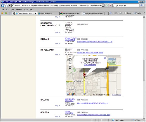
So, it's not possible to do a link, even on another site, owing to the data all being dynamically driven to the page. If you want to see what we have in production now (without mapping) go to www.besthf.com and use the dealer locator. Thanks, -Terri On Apr 30, 1:18 pm, "[email protected]" <[email protected]> wrote: > On Apr 30, 9:57 am, TerriLyn <[email protected]> wrote: > > > > > > > Hello, > > > I'm trying to get a map to display under the address for a business > > listing when a "Map It" link is clicked (opening a hidden div), and I > > currently have it working properly in IE. However, it is broken in > > Firefox. I have images for the problem. First the working IE model: > > >http://farm4.static.flickr.com/3335/3488442547_b30cbfbc77.jpg > > > And then the broken Firefox model. I have turned on in this image > > some block-level outlining tools, so you can see that despite it being > > all twisted around, there does seem to be a container of sorts being > > drawn with map controls and the Google logo inside it. > > >http://farm4.static.flickr.com/3299/3488442647_91aca111d7_o.jpg > > > Unfortunately, I cannot link to a "working site" due to limitations > > here at my work. However, below is all my map-related javascript, the > > "firing link" and the div tag. > > > Any suggestions on why this isn't working would be great. > > I suspect you are going to have to provide a link. Reasons > here:http://groups.google.com/group/Google-Maps-API/web/suggested-posting-... > > Remove any work related stuff from your example. > > > > > > > Thanks, > > -Terri > > > Javascript: > > <script type="text/javascript"> > > // ksa/sld google map > > var mapRow = 0; > > function showHideMap(tagId) { > > document.getElementById(tagId).style.display='none'; > > > } > > > </script> > > > <script src="http://maps.google.com/maps? > > file=api&v=2&key=<bean:write name="dealerLocatorForm" > > property="googleKey" filter="false" />" > > type="text/javascript"></script> > > > <script type="text/javascript"> > > > var map = new Array(); > > > var geocoder; > > if (GBrowserIsCompatible()) > > { > > geocoder = new GClientGeocoder(); > > } > > > var directionsPanel; > > var directions; > > var WINDOW_HTML_TXT; > > var gmarkers = []; > > var htmls = []; > > var to_htmls = []; > > var from_htmls = []; > > var i=0; > > var addrStr; > > > function initialize() { > > <logic:iterate id="output" name="dealerLocatorForm" > > property="dealers" indexId="index"> > > <logic:present name="output"> > > showHideMap('map_canvas<bean:write name="index"/>') > > </logic:present> > > </logic:iterate> > > } > > > function initializeMap() { > > <logic:notEqual name="dealerLocatorForm" property="option" > > value="default" > > > if (GBrowserIsCompatible()) > > { > > > map[mapRow] = new GMap2(document.getElementById > > ("map_canvas"+mapRow)); > > > //getting map center from database. > > map[mapRow].setCenter(new GLatLng(40.00000,-95.00000), 3); > > map[mapRow].addControl(new GSmallMapControl()); > > map[mapRow].checkResize(); > > geocoder = new GClientGeocoder(); > > > } > > </logic:notEqual> > > > } // initializeMap > > > // addAddressToMap() is called when the geocoder returns an > > // answer. It adds a marker to the map with an open info window > > // showing the nicely formatted version of the address and the > > country code. > > function addAddressToMap(response, html) { > > > var htm=html > > map[mapRow].clearOverlays(); > > if (!response || response.Status.code != 200) { > > // hide previously opened map > > document.getElementById > > ("map_canvas"+mapRow).style.display='none'; > > > if (response && response.Status.code == 500) > > alert("Sorry, Google Maps found a server error. > > Please call the > > dealer for more information."); > > else > > alert("Sorry, we were unable to map that address.\rPlease > > call the dealer for more information."); > > } else { > > > place = response.Placemark[0]; > > point = new GLatLng(place.Point.coordinates[1], > > place.Point.coordinates[0]); > > > var marker = new GMarker(point); > > > GEvent.addListener(marker, "click", function() { > > map[mapRow].openInfoWindowHtml(point, WINDOW_HTML_TXT); }); > > map[mapRow].setCenter(point, 13); > > map[mapRow].addOverlay(marker); > > map[mapRow].enableDoubleClickZoom(); > > map[mapRow].checkResize(); > > map[mapRow].addControl(new GSmallMapControl()); > > map[mapRow].openInfoWindowHtml(point, WINDOW_HTML_TXT); > > } > > } > > > // showLocation() is called when you click on the Search button > > // in the form. It geocodes the address entered into the form > > // and adds a marker to the map at that location. > > function showLocation(x, row) { > > > var address = x; > > // hide previously openedmap > > document.getElementById > > ("map_canvas"+mapRow).style.display='none'; > > > mapRow = row; > > initializeMap(); > > > geocoder.getLocations(address, addAddressToMap); > > > // open curent map > > document.getElementById > > ("map_canvas"+mapRow).style.display='inline'; > > > } > > > // populateInfo() is called when you click on the map it link > > // it passes the value of infotxt to the global variable of > > // WINDOW_HTML_TXT so that it can be displayed on the map. > > function populateInfo(srN, srA1, srC , srS, srZ) { > > > addrStr = escape(srA1)+",%20"+escape(srC)+",%20"+escape(srS)+", > > %20"+escape(srZ); > > > WINDOW_HTML_TXT = unescape(srN)+ "<br>"+srA1+"<br>"; > > WINDOW_HTML_TXT = WINDOW_HTML_TXT + srC +", "+srS+" "+srZ; > > WINDOW_HTML_TXT = WINDOW_HTML_TXT + "<br>"; > > WINDOW_HTML_TXT = WINDOW_HTML_TXT + "<a href=http:// > > maps.google.com/maps?daddr="+addrStr+" target=_blank class=maplink>Get > > Directions</a>"; > > > } > > > // findLocation() is used to enter the sample addresses into the > > form. > > function findLocation(address) { > > document.forms[0].q.value = address; > > showLocation(); > > } > > </script> > > > Body tag: > > <body onload="initialize()" onunload="GUnload()"> > > > Firing link: > > <a href="#" onClick="showLocation('<%=address%> <%=city%>, <%=state%> < > > %=zip%>',<bean:write name="index"/>);populateInfo('<%=name%>','< > > %=address%>','<%=city%>','<%=state%>','<%=zip%>');return false;" > > class="link">Map It</a> > > > Table row with div tag: > > <tr><td align="center" colspan="2"> </td><td align="center" > > colspan="3"><div id="map_canvas<bean:write name="index"/>" > > style="width: 400px; height: 300px; z-index:0"></div></td></tr>- Hide > > quoted text - > > - Show quoted text -- Hide quoted text - > > - Show quoted text - --~--~---------~--~----~------------~-------~--~----~ You received this message because you are subscribed to the Google Groups "Google Maps API" group. To post to this group, send email to [email protected] To unsubscribe from this group, send email to [email protected] For more options, visit this group at http://groups.google.com/group/Google-Maps-API?hl=en -~----------~----~----~----~------~----~------~--~---