On Sat, Feb 06, 2021 at 09:45:23AM -0800, [email protected] wrote:
Hello,
I noticed that this way: https://www.openstreetmap.org/way/342107973 has
such property
```
turn:lanes=through;left|through|through
```
It looks like an outdated information in maps according to photo provided
by me.
None of the available satelitte imagery in JOSM is clear enough for me
to offer advice on what /should/ likely be marked there.
The OpenStreetMap Wiki page that defines the contents of the turn:lanes
key is here: https://wiki.openstreetmap.org/wiki/Key:turn:lanes
You may wish to refer to the definitions as you decide what you believe
should be correct. Do note that OpenStreetMap has a *strict* rule of
"do not map for the renderer" (which also in large part applies to "the
router" as well).
I.e., OpenStreetMap (OSM) desires their map data to accurately reflect the
*on the ground* condition of the road in that intersection. If a map
renderer, or a route router, produces incorrect data, but the master
map data is correct per OSM's definitions, then OSM considers that a
bug in the render or routing engine, not a data problem for OSM.
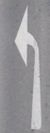
For the above key (turn:lanes=through;left|through|through) the
"through;left" tag says that the left most lane (looking in the
direction in which the OSM way points) is labeled with a lane marking
arrow that shows both "straight through" travel, and "left turn"
travel. I.e., this image from the OSM Wiki page I reference above:
https://wiki.openstreetmap.org/w/images/thumb/9/95/Turn-left-through.png/50px-Turn-left-through.png
So OsmAnd provided correct micro instruction.

So the correct property should be:
```
turn:lanes=left|through|through
```
If somebody confirm it I will fix it.
This OSM data will indicate that the left most lane is marked with an
arrow of a left turn only (no straight through travel) I.e., an arrow
of this type from the OSM Wiki page:
https://wiki.openstreetmap.org/w/images/thumb/4/4a/Richtungspfeil_Links.jpg/50px-Richtungspfeil_Links.jpg
The correct choice for OSM depends upon how the lane is marked/signed
on the ground in this intersection. As none of the satellite images
in JOSM are good enough for me to see any lane markings, I cannot
suggesst anything based on the satellite images.
If you travel through this intersection, then the next time through,
make note of how the lanes are marked, and then verify the OSM tagging,
using the Wiki page as a reference, correctly represents the markings
on the ground (i.e., painted on the lanes or signed on signage).
If OSM's tags differ from the signage -- then correcting OSM to match
the current on the ground signage is proper.
However, if OSM's tags match exactly the signage -- then modifying
OSM's tags would be a violation of OSM's rules.
This way https://www.openstreetmap.org/way/246174080 has such property:
```
turn:lanes=left|through|through;right
```
through;right means a sign/painted arrow of this form:
https://wiki.openstreetmap.org/w/images/thumb/d/d4/Turn-through-right.png/50px-Turn-through-right.png
And whether that is correct is again not something I can offer an
opinion on given the low quality of the JOSM satellite images in this
area.
--
You received this message because you are subscribed to the Google Groups
"OsmAnd" group.
To unsubscribe from this group and stop receiving emails from it, send an email
to [email protected].
To view this discussion on the web visit
https://groups.google.com/d/msgid/osmand/20210206182545.GQ2001%40d820.dp100.com.