On Fri, Jul 27, 2018 at 11:54 AM marc marc <[email protected]> wrote:
> a good idea would be to explain with a (as easy as possible) example
> why access=customers or private does not fit for your need.
> If it was what you did in your previous email, sorry but I didn't
> understand it, because your examples are too general, without
> explanation about existing tag problems
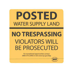
(Side note: I favour 'access=permit' over 'access=licence' because
it's spelt the same way on both sides of the Atlantic. Choosing a tag
that's spelt differently in US and UK English simply invites
misspellings.)

Here's an attempt at an explanation:

In the area that I'm mapping, there are rural regions - even with the
same land management - that have different regulatory regimes - and I
wish to render them differently.

They fall into major categories.  I'll also include specific examples
from the New York City water supply lands, because that specific land
owner has (or has had) examples in all the categories.

[1] 'access=private'.  These are private lands, or government-owned
lands for which public access is not routinely granted. They are
usually posted 'NO TRESPASSING' or similar verbiage - but would also
comprise farmers' fields and the curtilage of private houses. For
these, unless I have a relationship with the landowner, I have no
reason to expect access, and it would be regarded socially as being
quite strange to request it without a compelling reason.  On a hiking
map, I'd show these as 'out of bounds - off limits'.

The New York City water supply bureau owns large parcels of land in
this category - marked with uniform yellow NO TRESPASSING signs. that
look like http://www.nyc.gov/html/dep/images/resources/watershed_sign4.jpg
. I cannot show an OSM example because I haven't mapped them in OSM. I
don't map that sort of cadastre; instead, for lands, I consider
'access=private' to be the default.

Summary: "Ordinarily, no access to the general public"

[2] 'access=customers'. There are a number of clubs, resorts, ski
areas, and similar facilities that sell access (often labeled
something like a 'grounds membership' - offering the right to cross
the lands but none of the other club services). There is a reason that
I might be authorized as a member of the general public. (Of course,
'customers' may also include guests of members, conference attendees
at resorts, and similar prople.) Some government-owned lands fall
under this category - for instance, there are government
watershed-protection lands that ordinarily offer public access only in
hunting season to hunters who've paid for the privilege.

The New York City lands under this scheme are marked with
special-purpose signs like
http://www.nyc.gov/html/dep/images/resources/watershed_sign5.jpg .
These signs differ from area to area, since so do the ways of
obtaining the privilege to use the land.  I do see this as an actual
business-customer relationship (with the government as the business).
One such area is https://www.openstreetmap.org/way/422887495. It's not
tagged 'access=customers' at present, but I'd have no objection to
making the change.

Summary: "Access only to transact with the public-facing business that
occupies the land"

[3] 'access=permissive'. This more often applies to ways than lands,
but it there's no reason it couldn't apply to either.  Often, a
landowner will retain control of access but offers the general public
revocable rights to cross the land, usually in a specific corridor.
There will ordinarily be the indicia of a hiking trail, and frequently
there will be NO TRESPASSING signs on either side of the trail. Often,
there will be standing rules; for instance, one trail that I access
has a standing closure from October 15-December 31 of each year, plus
occasional closures when members of the family that owns the land are
hosting large gatherings.

There are several trails that cross otherwise-posted New York City
watershed lands. One example is
https://www.openstreetmap.org/way/285951320#map=15/42.0850/-74.2496,
which is on such lands between the end of the pavement on Jessup Road
until it starts following the boundary of the Mount Tobias wild
forest.  In the field, there are NO TRESPASSING signs on both sides of
the trail corridor from Jessup Road to the property corner, and then
NO TRESPASSING signs on the northeast side up to the junction with the
trails to Warner Creek and to Phoenicia. I've also been in there and
found that permission had been revoked temporarily, with signage that
looked like
http://www.nyc.gov/html/dep/images/graphics/active-forestry-management-proejct.png.
(The workers were friendly, and conducted my party through the
closure.) I concede that the 'highway=footway' there may need
'foot=permissive', but I'm not going to trouble to retag unless I
happen to find out whether a permanent easement exists for the trail.
(If there's a deeded easement, then of course it's 'access=yes' and
the closure was akin to closing a road for a brief construction
project.)

Summary: "Permission granted to (or traditionally not withheld from)
the general public, but revocable at will".

Side note: I also use this tagging for ways that are obviously used by
the general public but equally obviously intrude on private land, when
I'm not sure of the exact legalities. There are a fair number of
carriage roads that are regularly used by hikers, equestrians and
snowmobilists that are not on the official state maps, and whose legal
status is unclear.

[4] 'access=yes'. The lands and ways here are open to the general
public, usually without restriction (except for things like needing a
driver's license to drive, a fishing license to fish, and so on.) New
York City also operates many of these.
https://www.openstreetmap.org/way/424230668 is a specific example of
one that I've used. They are signed like this
http://www.nyc.gov/html/dep/images/resources/watershed_sign3.jpg - and
it's a standard sign, that appears on at least a couple of hundred
parcels.

Obviously, things like the public parks, the state forests, and many
of the Wild Forests and Wilderness Areas are also access=yes.

Summary "The general public has a right to enter, with no advance formalities."

[5] 'access=permit'. Now I come to the category that isn't covered:
lands that are open to the public, for which permission will not be
refused arbitrarily, They have a permission regime, but generally it's
fee-free or carries only a nominal administrative cost, and there's no
specific qualification required. (Some may have conditions such as
refusing permits to those who have repeatedly broken the permit rules,
or to convicted felons, but not anything arbitrary.) The system is
ordinarily very straightforward - booking a date, or filling out
contact information on a web site, or stopping at the desk at a ranger
station and registering, or even just filling out a two-part form at a
trailhead and dropping one part in a letter box. For the New York City
lands, it's entering contact information on a web site, the permit is
good for several years, and it applies to many dozens of sites. Those
sites, too, have standard signage, looking like
http://www.nyc.gov/html/dep/images/resources/watershed_sign2.jpg.  A
sample area would be https://www.openstreetmap.org/way/481477548.

Obtaining the permission - to me, and to a number of my colleagues
here - doesn't feel like 'access=private' (or even
'access=customers'). It's public land. The public has a right of
access. It's simply that there are particular hazards or particular
fragile conditions that have prompted the government to impose a
condition of obtaining the permit - which serves as proof that the
holder was informed of the particular issues with accessing the area.

There are also ways that ought to have similar tagging - and the
poster who started this thread gave an example from Hungary.   One
example from nearer to home for me is the Limekiln Lake - Cedar River
Road, that runs through the corridor at
https://www.openstreetmap.org/relation/6370357. It's gated at both
ends, with signs reading "STOP: All vehicles must register."  While
there is a gatehouse http://i65.tinypic.com/2enq9ew.jpg, it is seldom
staffed nowadays. Instead the protocol is ordinarily to get out, fill
out the permit form at the kiosk, open the gate, drive through, and
close the gate behind you. This scheme is mostly to ensure that
drivers are informed of the specific hazards: the road is not paved,
goes through a corridor between wilderness areas, has no cellular
service and no facilities. Many drivers are not comfortable with
driving in a region where there will be no ready way to summon help in
the event of an accident.

Summary: "The general public has a right to enter, but specific
conditions require compliance with formalities in advance."

Of the other access tags (private, customers, permissive, public), the
one that is most similar to 'access=permit' is 'access=public.' It's
not 'access restricted to customers', its 'special regulatory
formalities in place because of fragile or hazardous conditions.'

Rendering 'access=permit' with a different treatment on maps that are
targeted for outdoor recreationists has obvious benefits, since the
fact has obvious implications for trip planning. It's far from 'don't
go here," as 'access=private' would be; and neither is it, "hike here
only if you're staying at the resort/a member of the club/a hunter
who's bought a pass". It's simply "watch out, there are formalities to
be complied with." It's to be expected that a traveler will be able
readily to comply with the formalities. In all the cases that I have
in mind, it's a mere regulatory scheme on top of land that belongs to
the public, that the public has the right to access.

If you still find this discussion "too general", I'd wonder what
specific information you need. In an earlier thread, there was one
objector who asserted that the idea could be considered only if
accompanied by a detailed schema of all possible permit conditions.
Since the variety of conditions seems limited only by human
imagination, this surely felt like a way of blocking the proposal by
insisting on answers to unanswerable questions. I'm hoping that's not
what you're after, and that there's really something missing in my
reasoning.

Please recall that this topic appears regularly - and that some people
who agree with my position are well aware that the 'private',
'permissive' and 'customers' tags exist. Not all of us are entirely
ignorant of existing tagging schemes. Some of us truly do believe that
we have a condition here that is actually distinct from 'yes',
'private', 'permissive' and 'customers'.  In this posting, I've given
concrete examples of where I'd use all five tags, on lands all
belonging to the same government agency.

_______________________________________________
Tagging mailing list
[email protected]
https://lists.openstreetmap.org/listinfo/tagging
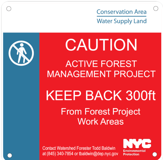
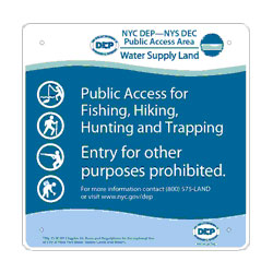
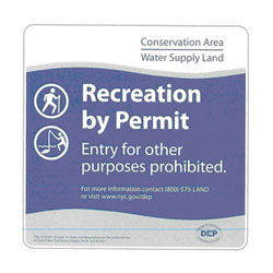