My idea was only trying to avoid to invent tag values for OSM without
consulting what other, technically more competent bodies, have done before.
Looks as the FAO classification could have  served as template for OSM
tagging approach years back. But we now are only after tag value for bare
soil, not a whole new table of  landcover values.
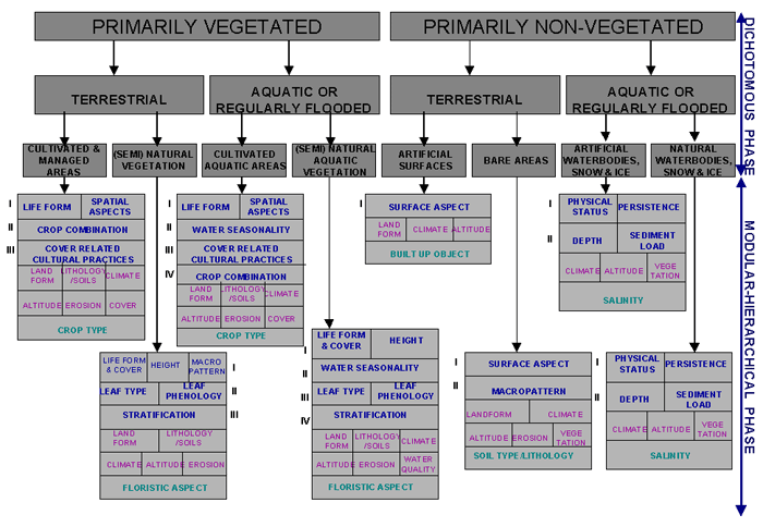
On Thu, 16 Jul 2020, 12:06 Michael Montani, <[email protected]> wrote:

> According to the document you shared
> <http://www.fao.org/3/x0596e/X0596e02a.htm#P1974_116516>, bare soil is
> mentioned in:
> *Primarily non-vegetated > Terrestrial > Bare areas*
>
> And within *Bare areas*, *Bare soil* is an available category, being
> distinguished by *Bare rock* whether the terrain is consolidated or not.
> Within *Bare soil*, further classification is made depending on a
> "stoniness" percentage (5 to 40% *Stony*, >40% *Very stony*) and on soil
> macropatterns (II level).
>
> I think this could be useful material for us to make a decision.
> *natural=bare_soil *targeting all the areas of unconsolidated ground
> material could be used whether or not a groundy area hasn't already a tag
> that suits better its representation (e.g. *natural=wetland +
> intermittent=yes*, *landuse=quarry*...).
>
> Thanks,
>
> --
> *Michael Montani*
> GIS Consultant, *Client Solutions Delivery Section*
> *Service for Geospatial Information and Telecommunications Technologies*
> United Nations Global Service Centre
> United Nations Department of Operational Support
>
> Brindisi | Phone: +39 0831 056985 | Mobile: +39 3297193455 | Intermission:
> 158 6985
> E-mail: [email protected] <[email protected]> | www.ungsc.org
>
> ------------------------------
> *Da:* Martin Koppenhoefer <[email protected]>
> *Inviato:* mercoledì 15 luglio 2020 10:08
> *A:* Tag discussion, strategy and related tools <[email protected]
> >
> *Oggetto:* Re: [Tagging] Feature Proposal - RFC - (Ground)
>
>
>
> Am Mi., 15. Juli 2020 um 09:45 Uhr schrieb Martin Koppenhoefer <
> [email protected]>:
>
> If you are interested in reading some interesting thoughts about landcover
> classification, there is the FAO landcover classification system, thought
> to be useful globally:
> http://www.fao.org/3/X0596E/X0596e00.htm
>
>
>
>
> there are only 8 main classes:
> http://www.fao.org/3/X0596E/X0596e10.gif
>
> and you can easily determine them through a decision matrix:
> 1. primarily vegetated or primarily non-vegetated?
> 2. terrestrial or aquatic/flooded regularly?
> 3. cultivated/man made/artificial or natural?
>
> then they add additional properties like life forms, crops, leaf types,
> climate, ...
>
> From the combination of these properties and classes, detailed land cover
> classes are determined:
>
>
> http://www.fao.org/3/x0596e/X0596e02a.htm#P1974_116516
>
> E.g. here:
>
> TABLE 3.4
> *Example of the formation of land cover classes*
>
> *EXAMPLE: "NATURAL AND SEMI-NATURAL TERRESTRIAL VEGETATION" (A12)*
>
> *Classifiers used*
>
> *Boolean formula*
>
> *Standard class name*
>
> *Code*
>
> Life form and cover
>
> A3A10
>
> Closed forest
>
> 20005
>
> Height
>
> A3A10B2
>
> High closed forest
>
> 20006
>
> Spatial distribution
>
> A3A10B2C1
>
> Continuous closed forest
>
> 20007
>
> Leaf type
>
> A3A10B2C1D1
>
> Broad-leaved closed forest
>
> 20095
>
> Leaf phenology
>
> A3A10B2C1D1E2
>
> Broad-leaved deciduous forest
>
> 20097
>
> 2nd layer: LF, C, H
>
> A3A10B2C1D1E2F2F5F7G2
>
> Multi-layered broad-leaved deciduous forest
>
> 20628
>
> 3rd layer: LF, C, H
>
> A3A10B2C1D1E2F2F5F7G2
>
> Multi-layer broad-leaved deciduous forest with emergents
>
> 20630
>
> Cheers,
> Martin
>
> PS: And the best: LCCS comes as a run time application, you do not need to
> have virtual basic installed !!11!!!
>
> _______________________________________________
> Tagging mailing list
> [email protected]
> https://lists.openstreetmap.org/listinfo/tagging
>
_______________________________________________
Tagging mailing list
[email protected]
https://lists.openstreetmap.org/listinfo/tagging