Cycling to work this week I have come across a more direct way to town, but
also a road which I am not sure how to map properly in OSM.
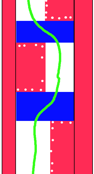
At the moment the whole street is mapped as highway=pedestrial with lcn=yes
- but in reality it's not that simple.

The road used to be the main road into the city centre from Trent Bridge but
has now been pedestrianised (the following images might help you understand
my comments)

Google Street View :

http://maps.google.co.uk/?ie=UTF8&ll=52.940734,-1.140834&spn=0.003246,0.009645&t=h&z=17&layer=c&cbll=52.940734,-1.140834&panoid=nqz0Qta4kazDIF3Ok2sN4w&cbp=12,324.6,,0,0.8

My aerial drawing : http://kjs.me.uk/3rdparty/osm/arkwrightwalk.png

Basically the existing "sidewalks" are still in situ and the paving allows
you to see where the edges are likely to have been (see the red bars at
either side of my image) and then at various places along the road two of
the old lanes have been paved over with a raised island of flagstones (see
the red blobs in the road) which effectively become an area for the local
kids to play football on and also walkway and the remaining two lanes have
become a cycle path (the white area) - but every 50 meters or so the islands
end on one side of the road and jump to the other-side of the road, and in
between the two islands the former four lanes of the road become a raised
sleeping policeman for about 5 meters (see the blue boxes) with the ramps
not being opposite one another (i.e. the ramp on one side is opposite the
pedestrian area on the other).

How on earth do I map and tag this street properly? - is it just a case of
drawing a road though it with all the kinks being followed and the speed
humps being added as usual setting sidewalk=no, then making the pedestrian
islands highway=pedestrian, area=yes (with the trees and bollards also
mapped) and then adding the sidewalks as two extra walkways running in
parrall with links across going across the middle of the sleeping policeman
(the sleeping policeman seem to be placed where paths from the sides join
the road, presumably to allow pushchairs and wheelchairs to cross easily).

Also the main road doesn't appear to have anything explicitly banning motor
vehicles either, although I've only seen two along the length of it (both
parked) - but the road is obviously laid out to discourage motor vehicle use
- should this be mapped in any way (this is a moot point really as the road
hits a (currently unmapped) wall before it permits motor vehicles again -
need to remember to check next week if there is a gap in that wall to allow
pedestrians through.

Kev
_______________________________________________
Talk-GB mailing list
[email protected]
http://lists.openstreetmap.org/listinfo/talk-gb