Sounds like a highway=living_street to me (but highway=pedestrian would be fine)
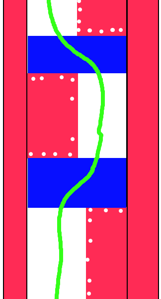
In general you need to tag the characteristics of the whole street if
you can. Micro-mapping is a bonus, and you need to be careful not to
make it unintelligable to the data user at the "whole-street" level

On Sat, Apr 2, 2011 at 9:08 AM, Kev js1982 <[email protected]> wrote:
> Cycling to work this week I have come across a more direct way to town, but
> also a road which I am not sure how to map properly in OSM.
>
> At the moment the whole street is mapped as highway=pedestrial with lcn=yes
> - but in reality it's not that simple.
>
> The road used to be the main road into the city centre from Trent Bridge but
> has now been pedestrianised (the following images might help you understand
> my comments)
>
> Google Street View :
>
> http://maps.google.co.uk/?ie=UTF8&ll=52.940734,-1.140834&spn=0.003246,0.009645&t=h&z=17&layer=c&cbll=52.940734,-1.140834&panoid=nqz0Qta4kazDIF3Ok2sN4w&cbp=12,324.6,,0,0.8
>
> My aerial drawing : http://kjs.me.uk/3rdparty/osm/arkwrightwalk.png
>
> Basically the existing "sidewalks" are still in situ and the paving allows
> you to see where the edges are likely to have been (see the red bars at
> either side of my image) and then at various places along the road two of
> the old lanes have been paved over with a raised island of flagstones (see
> the red blobs in the road) which effectively become an area for the local
> kids to play football on and also walkway and the remaining two lanes have
> become a cycle path (the white area) - but every 50 meters or so the islands
> end on one side of the road and jump to the other-side of the road, and in
> between the two islands the former four lanes of the road become a raised
> sleeping policeman for about 5 meters (see the blue boxes) with the ramps
> not being opposite one another (i.e. the ramp on one side is opposite the
> pedestrian area on the other).
>
> How on earth do I map and tag this street properly? - is it just a case of
> drawing a road though it with all the kinks being followed and the speed
> humps being added as usual setting sidewalk=no, then making the pedestrian
> islands highway=pedestrian, area=yes (with the trees and bollards also
> mapped) and then adding the sidewalks as two extra walkways running in
> parrall with links across going across the middle of the sleeping policeman
> (the sleeping policeman seem to be placed where paths from the sides join
> the road, presumably to allow pushchairs and wheelchairs to cross easily).
>
> Also the main road doesn't appear to have anything explicitly banning motor
> vehicles either, although I've only seen two along the length of it (both
> parked) - but the road is obviously laid out to discourage motor vehicle use
> - should this be mapped in any way (this is a moot point really as the road
> hits a (currently unmapped) wall before it permits motor vehicles again -
> need to remember to check next week if there is a gap in that wall to allow
> pedestrians through.
>
> Kev
>
> _______________________________________________
> Talk-GB mailing list
> [email protected]
> http://lists.openstreetmap.org/listinfo/talk-gb
>
>

_______________________________________________
Talk-GB mailing list
[email protected]
http://lists.openstreetmap.org/listinfo/talk-gb