On 02/04/2011 09:08, Kev js1982 wrote:
Cycling to work this week I have come across a more direct way to
town, but also a road which I am not sure how to map properly in OSM.
At the moment the whole street is mapped as highway=pedestrial with
lcn=yes - but in reality it's not that simple.
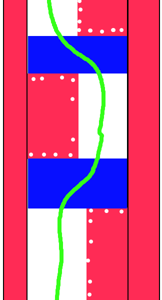
The road used to be the main road into the city centre from Trent
Bridge but has now been pedestrianised (the following images might
help you understand my comments)
Google Street View :
http://maps.google.co.uk/?ie=UTF8&ll=52.940734,-1.140834&spn=0.003246,0.009645&t=h&z=17&layer=c&cbll=52.940734,-1.140834&panoid=nqz0Qta4kazDIF3Ok2sN4w&cbp=12,324.6,,0,0.8
<http://maps.google.co.uk/?ie=UTF8&ll=52.940734,-1.140834&spn=0.003246,0.009645&t=h&z=17&layer=c&cbll=52.940734,-1.140834&panoid=nqz0Qta4kazDIF3Ok2sN4w&cbp=12,324.6,,0,0.8>
My aerial drawing : http://kjs.me.uk/3rdparty/osm/arkwrightwalk.png
First off, going on the streetview, I wouldn't say the road with reddish
colouring & 'cobblestones' (shown white on your sketch) is
pedestrian/cycle exclusive. It appears that vehicles, such as
deliveries, are allowed. I think there would be bollards if not.
Does the signpost give any clues?
Bit unsure about the blue bits. It seems there's no bollards so in
theory could a vehicle be allowed to cross it, albeit very slowly. What
type of kerbs do these blue areas have.
Also if there's no a gap in the wall, how do you cycle through it?

Does the LCN have a number? If so tag it, preferably in a relation.
General mapping tip: You can go as detailed as you like - if it's
physical, you can map it (given time & patience).
Personally I don't tag pavements that are not separated from the road by
grass verge etc.
Cheers
Dave F.

_______________________________________________
Talk-GB mailing list
[email protected]
http://lists.openstreetmap.org/listinfo/talk-gb