By the way, if anyone finds the feature useful and wants to fix up some of
the nagging issues or add on, feel free to fork on github and make a pull
request :P
On Wed, Apr 11, 2012 at 5:36 PM, Evan Battaglia <[email protected]> wrote:
> Hi Robert,
> Thanks for contributing and keeping it alive :)
>
>
>
> > I don't quite understand your use case - are you printing these maps out?
> Yes.
> > It's a bit different from how I use things, but I'm sure I'll work it out
> I've learned that people use Viking in radically different ways -- like
> whoever wrote the "Using the Viking jpeg module" for using sailing charts.
> The use case is that I'm designing a long-distance hiking route by using
> tracks on Topo maps. I'll probably be doing a lot of editing, and when I'm
> ready I want to make sure I create maps covering all the sections. With the
> ImageBoxLayer I see the boxes (ImageBoxLayer draws a box for the area that
> will be made into a map) and the trails from a zoomed out position and make
> sure I have maps covering everything and that they are all the right size,
> and can then generate the map image files. Otherwise, I everytime I wanted
> to regenerate the maps, I would have to carefully go to a position, use the
> generate tool and input the right zoom factor, and width and height and
> filename... for each of the 300 maps I'll probably make. And I couldn't be
> sure they cover all the area I want.
>
>
> > ATM if you put Viking into a select mode (click on the pointer next
> ruler on the tool bar) use can select a track by clicking on it (well any
> of actual trackpoints - which if you're in zoomed in close). This
> highlights the track in the layers panel and also shows some information in
> the statusbar including the track name - if your screen is big enough :)
> > how does the 'middle' of track relate to track? Depends on shape of the
> track - line, circle, other - the 'middle' of different tracks can easily
> overlap - and the 'middle' may not seem obvious to the user.
> Right, but when the map is generated you don't have the lengths of the
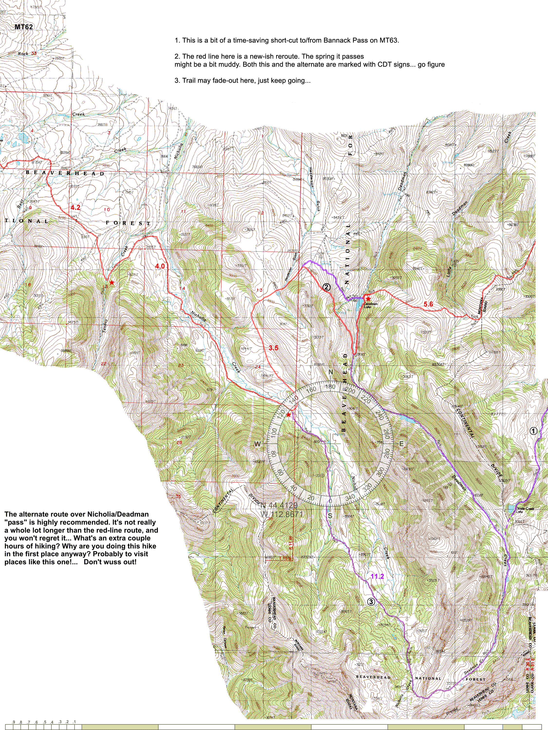
> trails. I want to make something like Jonathan Ley's maps (
> http://www.phlumf.com/travels/cdt/mt62.gif) or really any hiking map
> where the length of a trail is noted right there. It's true that I may have
> to do something tricky to come up with a good position for the length text
> -- it may overlap with other trails, etc. I might even have to define a
> position for each track. It might not be practical at all, I haven't
> thought too much about it. But for my purposes, it would really nice to
> have maps that I can look at and instantly see the mileage difference
> between taking two alternate routes, and to quickly add up numbers to see
> how long a section is.
>
> Evan
>
> On Wed, Apr 11, 2012 at 1:52 PM, Robert Norris <[email protected]>wrote:
>
>>
>>
>> >Hi,Some of you may recognize my name, I came up with the name "Viking"
>> :) but have not been so active in recent years...
>>
>> Excellent to still hear you are alive and kicking :)
>>
>> > https://github.com/evanbattaglia/viking/tree/imageboxlayer
>> > A sample compass rose is in doc/sample-compassrose.png.
>>
>> I'll investigate it.
>> However I'm (we are?) hoping to release a 1.3 version imminently, so it
>> would be for 1.4
>>
>> > Let me know if any of you have questions about this feature.
>>
>> I don't quite understand your use case - are you printing these maps out?
>>
>> It's a bit different from how I use things, but I'm sure I'll work it out
>>
>> > Just FYI, some of the features I would like to implement that I believe
>> are not in Viking, and may or may be working on depending on time:
>>
>> > * labeling a track with its length, probably in the middle, and
>> showing the endpoints more prominently. Again, this is to generate map
>> similar to http://www.phlumf.com/travels/cdt/cdtmaps.shtml (see sample
>> http://www.phlumf.com/travels/cdt/mt62.gif)
>>
>> Note you get tooltip style info which *includes the length*, when you put
>> the mouse over the track name in the layers panel.
>>
>> ATM if you put Viking into a select mode (click on the pointer next ruler
>> on the tool bar) use can select a track by clicking on it (well any of
>> actual trackpoints - which if you're in zoomed in close). This highlights
>> the track in the layers panel and also shows some information in the
>> statusbar including the track name - if your screen is big enough :)
>>
>> Personally I'd find track labels confusing with many tracks:
>> how does the 'middle' of track relate to track? Depends on shape of the
>> track - line, circle, other - the 'middle' of different tracks can easily
>> overlap - and the 'middle' may not seem obvious to the user.
>>
>> However it could be useful, but at least it should be configurable -
>> maybe defaulting off for the layer. [Configurable layer defaults are in the
>> wish list/roadmaps].
>>
>> Note there is this my idea in the Wiki for the 1.4 roadmap
>> "Show distance along a track as markers (maybe 'auto' waypoints / or just
>> gui elements) in friendly scaled units if desired."
>> I can expand in more detail this idea if you're interested - it seems
>> very similar to your idea.
>>
>> Agreed the start and end points should be clearer - maybe the size needs
>> relating to the current zoom level?
>>
>> Also maybe having the option to show arrows to indicate track direction
>> could be nice too.
>>
>> The Roadmap / Ideas / Wishlist are a little scattered in the wiki - I'll
>> clean it up somewhat.
>>
>> > * Ability to merge all TRWlayers under a particular AggregateLayer
>>
>> Yes
>>
>> > * Have a tool that can connect trails to find the shortest path
>> amongst your tracks using Dijkstra's algorithm, A*, etc. It would also
>> allow for trails which don't >exactly touch by setting a threshold wherein
>> two track endpoints are deemed "close enough" and an edge connecting them
>> in the graph is created. I want this >to be able to choose between
>> different combinations made up of tracks and to see what the shortest route
>> would be. It would also be useful for reconnecting a >track that has been
>> split up into segments that all touch each other but are unordered.
>>
>> Sounds complicated.
>> Do it if you want.
>>
>>
>> >BTW, one question -- is there a reason we are still using the
>> sourceforge git repo? We use github at work and it's really nice because
>> people can make forks and >do pull requests easily, see the network graph,
>> etc.
>>
>> Historical.
>>
>> Well it hosts the Wiki, various trackers and of course this mailing list!
>>
>> The beauty of distributed development, one can fork off sourceforge (code
>> only) and host it anywhere else.
>> At the moment one probably has to clone from sourceforge via ssh onto a
>> local machine and then push it to github (ssh or http)
>>
>> Obviously as Evan has done it's easier to fork my (rnorris) github repo.
>>
>> PS I would like make a personal thanks to Evan for starting this project
>> and making it as good/useful such that I became so hooked, I just had to
>> start contributing back.
>> PPS What ever happened to Quy Tonthat?
>>
>
>
>
------------------------------------------------------------------------------
For Developers, A Lot Can Happen In A Second.
Boundary is the first to Know...and Tell You.
Monitor Your Applications in Ultra-Fine Resolution. Try it FREE!
http://p.sf.net/sfu/Boundary-d2dvs2
_______________________________________________
Viking-devel mailing list
[email protected]
https://lists.sourceforge.net/lists/listinfo/viking-devel
Viking home page: http://viking.sf.net/