On Tue, Sep 1, 2020 at 9:03 AM Frederik Ramm <frede...@remote.org> wrote:
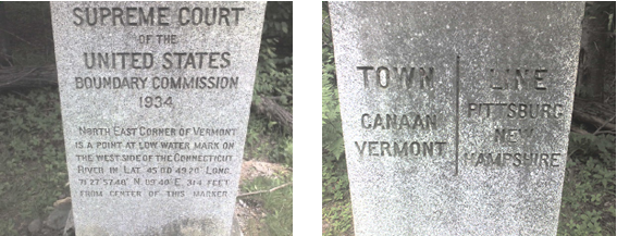
> On 01.09.20 14:40, Kevin Kenny wrote:
> > We don't map cadastre at least partly out of respect for personal
> > privacy - something that is not at issue with government-owned land.
>
> I think I'm with Joseph here, we don't map cadastre stuff also because
> it makes no sense for us to become a copy of data that is
> authoritatively kept elsewhere. OSM's strength is that data can be
> edited by everybody based on observations. Data for which the sentence
> "if you edit this it will become wrong" is true should not be in OSM.
>

In my area, I deal with - and have imported - several 'authoritative' data
sets, and I personally do _not_ consider them all that authoritative, since
they are digitizations of descriptions of what is in the field. (Our land
title does not work by latitude and longitude; the authoritative reference
is a verbal description of the 'metes and bounds' - the physical objects in
the field that define the property line. A land surveyor must recover those
objects in order to do a formal survey of the line; generally speaking, the
surveyors choose or make marks that will last for decades or centuries, and
make redundant marks so that a line can be struck from partial recovery.)
They're quite often some distance away from reality.

I deal routinely with cases where there is public land managed by different
authorities, with shared boundaries. The boundaries very seldom align, and
occasionally are far off.

In many of these cases OSM has an opportunity to improve the government
data.  A mapper can analyze the conflict, sort out the different data
sources, perhaps visit the site in the field, and produce a result that is
more accurate than any of the government data sets. It's been pretty quiet,
but I know that there some corrections from OSM have flowed back into some
of the government data sets that I use.

A handful of particular examples:

https://www.openstreetmap.org/user/ke9tv/diary/391486 - reconstructing a
town line by comparison of old maps from the Federal government (three
versions of the USGS topo maps), the State government (the topo maps from
the State department of transportation, wilderness boundaries from the
Department of Environmental Conservaion, tax plats from two counties, and
historic maps of the old Dutch land grants.

https://www.openstreetmap.org/user/ke9tv/diary/42951 - clarifying the
boundary between a State Park and a military reservation - needed to warn
hikers of trespassing - which was incorrect in *all* available data sources
and needed some field work to recover.

(no diary entry) Unifying the boundaries of the West Point military
reservation https://www.openstreetmap.org/relation/175474 with the
surrounding lands, which include three state parks, a protected forest
belonging to an NGO, a cemetery, a golf course, and several transportation
corridors. The boundaries of all these objects had been previously on the
map from other imports and from hand-mapping - and conspicuously failed to
align. The data from the US Government were perhaps the worst of the lot -
and in fact, I got conflicting data from multiple agencies. I'm still not
100% sure of the totality of the boundary - it's a massive project - but
the very worst inconsistencies did indeed have their corners verified in
the field. (Every so often, someone, without discussion, reimports one or
another government data set on top of this hard work, and I'm grateful to
the DWG for the times that they've helped me get it sorted again.) One
thing that was particularly satisfying about this one is that Black Rock
Forest had previously been a blank spot on the map. I heard from a local
mapper who had learnt about its existence from OSM - and within a few
months after I added the boundary, he and others had filled in quite a lot
of detail within it!

(no diary entry again) I've revised the boundaries of a number of the
Wilderness and Wild Forest areas in the Adirondacks, because they clearly
were following natural features, and were misaligned to those features
(e.g., islands in the lakes).  That's gone as far as to remove one boundary
line from the Lake George Islands property because that island itself was
destroyed in a storm some years ago. (The State GIS people had simply not
got around to making the change.)

(no diary entry) OSM had, more or less correctly, the expansion of the High
Peaks Wilderness https://www.openstreetmap.org/relation/6360488 into the
area around the Boreas Ponds about six months before the state GIS
department released the updated data set.  I entered it by obtaining copies
of the tax plats of the former Finch Pruyn company, and hand-digitizing the
areas that had been transferred to New York State.  (I reconciled the
differences when they did; I didn't leave my interim lines in place.)


In your criticisms of imports, you often describe them as dead data. I
don't agree.  In fact, any time I've done an import, it's because I want to
improve on what is available. The import is the first step, not the last.
Far from 'if you edit this, it will become wrong', I'm doing the import to
make it less wrong - in essence, bringing the dead data in a government GIS
system back to life!

This misunderstanding may reflect a difference between American and German
practice. Over here, very little cadastral data is managed in detail by a
central authority, and when the data are consolidated, there's very much an
ongoing dialogue about them. OSM is a near-ideal place for citizen-mappers
to record their findings - and various governments do indeed consult it.
The flow of information is in both directions.

And you'd be amazed how messy land title is.  A deed of sale specifies the
property being transferred with a verbal description and possibly a survey,
and contains a reference to a page in the county recorder's books of maps.
That's enough information for the tax authorities. Most land buyers
purchase 'title insurance' that protects them against conflicting claims to
the land. If there are actual property line disputes that a survey can't
resolve to the parties' satisfaction, it goes to the courts. Otherwise, we
don't have any authoritiative government registry of title - usually, even
of the land that the government owns! It's all verbal descriptions on the
deeds that conveyed the land title.

(Feel free to stop reading. Illustrative anecdotes follow.)

My uncle feuded with a neighbour over a property line for forty years.
When he passed away and my brother inherited the farm, my brother very much
wanted to mend fences, both literally and figuratively. He and the
neighbour brought in a forester to recover the line, which was done quite
efficiently indeed. My brother was even able to pay the guy in timber,
since he found out that he owned a stand of red oaks that he thought
belonged to the neighbour, so he got not only a survey, but a haul road,
for no cash out of pocket - the forester was happy to get a few truckloads
of hardwood suitable for furniture-making. That sort of thing is pretty
typical of land title in the US. (Brother and the neighbour are now quite
good friends, since the two irascible old men are long gone.)

That sort of thing goes up to administrative boundaries at the highest
level. The state line between Vermont and New Hampshire was disputed from
1777 to 1934, when the US Supreme Court finally appointed a survey
commission to settle the issue. (Every seven years, the state attorneys
general meet at a point on the border to reaffirm that the boundary remains
fixed. https://www.deseret.com/2012/5/14/20412784/)

https://www.hallam-ics.com/hs-fs/hubfs/cornermarker.png?name=cornermarker.png


The obverse reads: "TOWN LINE: CANAAN, VERMONT | PITTSBURG, NEW HAMPSHIRE"
The reverse:
SUPREME COURT
of the
UNITED STATES
BOUNDARY COMMISSION
1934
North East Corner of Vermont
is a point of low water mark
on the west side of the Connecticut
River in Lat. 45°00'49.20" Long.
71°27'57.40". N 09°40'E 314 feet
from center of this marker.

And it's that block of granite, and that turn of the river, and the dozens
of other blocks of granite, that define the line, not some map in
Washington.

https://forums.geocaching.com/GC/index.php?/topic/73161-1934-us-supreme-court-border-survey-mark/
is
a tablet on another block of granite:
"THE SUPREME COURT OF
THE UNITED STATES
VERMONT-NEW HAMPSHIRE
BOUNDARY COMMISSION
REFERENCE MARK
PENALTY FOR DISTURBING
NUMBER 37
State Line is 75 ft
→+→
S 89°48' E
from center of this marker

 --
73 de ke9tv/2, Kevin
_______________________________________________
Talk-us mailing list
Talk-us@openstreetmap.org
https://lists.openstreetmap.org/listinfo/talk-us