This is a MapHist list message (when you hit 'reply' you're replying to the
whole list)
o + o + o + o + o + o + o + o + o + o + o + o + o + o + o + o + o + o + o +
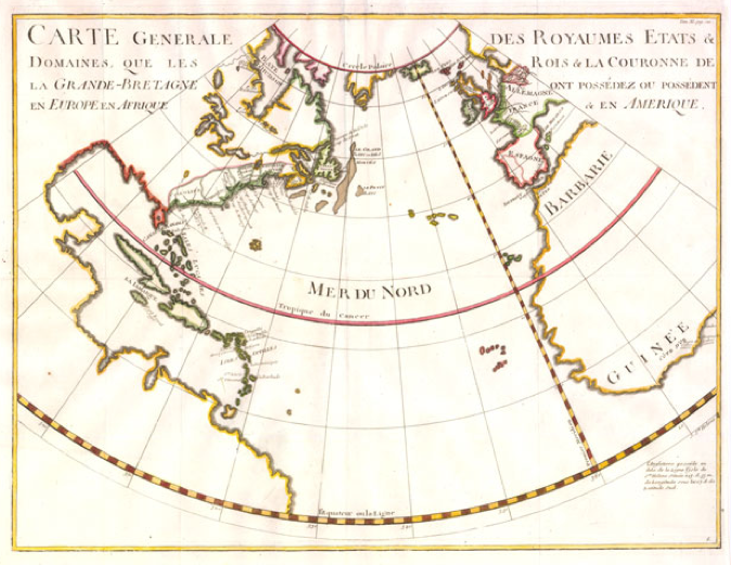
To confuse matters further, WorldCat (via FirstSearch) has two entries
for the map, dated 1800 (likely an error?--seems to have page markings
as Tome II, pag. 1, but no linked image), and a second located at the
BNF dated 1713 (do your image measurements match?). That latter entry is
also in Gallica, and copied below, and was a fairly recent online entry.
They have a link to their image:
http://gallica.bnf.fr/ark:/12148/btv1b5971470x.r=.langEN. That can be
manipulated for higher resolution, although the download for me is a bit
slow this morning, so I did not look carefully. The map could have
appeared in both the Dutch and British (later) editions of Rapin's work.
The map itself might have been copied from an earlier publication. Does
your map have any indication of volume and page number in the margins?
   Full bibliographic record

   Title : Carte Générale des Royaumes, Etats et Domaines, que les Rois
   et la Couronne de la Grande-Bretagne ont possédez ou possédent en
   Europe en Afrique et en Amérique

   Publisher : [s.n.]

   Date of publication : 1713

   Subject : Monde -- Colonies anglaises Search in Gallica all
   documents with this subject

   Type : document cartographique,carte,image fixe

   Language : French

   Format : 1 carte : avec limites en rose ; 41 x 54 cm

   Format : image/jpeg

   Copyright : domaine public

   Identifier : ark:/12148/btv1b5971470x

   Source : Bibliothèque nationale de France, département Cartes et
   plans, GE BB 565 (1, 46)

   Relation : Appartient à : Atlas geographique, Contenant les
   Hémisphéres célestes et terrestres ; les Cartes marines du grand
   Océan ; la Carte générale d'Europe, divisée en ses Etats ; celles
   des Côtes de la Mer méditerranée, et des Iles Britanniques. Tome I.

   Relation : http://catalogue.bnf.fr/ark:/12148/cb42214776f

   Coverage : Monde (parties)

   Provenance : bnf.fr


   Date de mise en ligne : 24/01/2011

                               Joel Kovarsky

On 9/29/2011 5:21 AM, Vladimiro Valerio wrote:
This is a MapHist list message (when you hit 'reply' you're replying to the
whole list)
o + o + o + o + o + o + o + o + o + o + o + o + o + o + o + o + o + o + o +


Daniel and all,
just one short, brief, remark.
Before Gaspard Monge published his fundamental treatise /Géometrie
Descriptive/ in 1799 (an VII of Republican Calendar) the method of
orthogonal projections were used almost all over the world since the
first millennium Before our Era. Monge put together and gave a
geometrical structure, founded on principles, to all the disseminated
pieces of orthographic representations.
It means that well before Monge we may found "perfect" orthogonal
projections (see Durer in 1525, also Piero della Francesca in 1475 c.
and . . . so on back) even if they are not so defined or claimed!
The way in which the human mind may reach goals and scientific
conquests are quite different. Philosophically speaking, we may reach
the truth in several ways.
with sympathy
vladimiro


Il giorno 29/set/2011, alle ore 08.40, Daniel Strebe ha scritto:
This is a MapHist list message (when you hit 'reply' you're replying
to the whole list)
o + o + o + o + o + o + o + o + o + o + o + o + o + o + o + o + o + o
+ o +
Colleagues:
I would appreciate help from those with this publication in their
collection:
“L’Histoire d’Angleterre”, Paul de Rapin-Thoyras, 1724 and later

with Volume XI, p. 121, containing the map titled,
“Carte Generale des Royaumes Etats & Domaines, que les Rois & La
Couronne de la Grande-Bretagne ont Possédez ou Possédent en Europe en
Afrique & en Amerique”
I am studying this map, stated by the sell to have been published
circa 1736.
The problem is that the map is impossible. I bought the map as a
curiosity because it is drafted on a conic projection, which were
rarely used at the time. When I received the map I wanted to
ascertain which specific conic it is. I am bemused to report that,
with a high degree of confidence, the map is drafted on a Lambert
conformal conic with standard parallel of 75°.
The problem with this assessment is that the projection and the
mathematical principles that motivate it were supposedly unknown in
1736. The projection, the mathematics for it, and the entire mindset
that motivates it, were published by Johannes Heinrich Lambert in
1772. Lambert’s treatise is considered the seminal work in
mathematical cartography. The projection wasn’t supposed to be
possible before that publication.
My questions:
• Does this map exist in editions of “L’Histoire d’Angleterre” prior
to 1772?
• Does the map look substantially like this?
http://mapthematics.com/Downloads/CarteGenerale.png

Thanks & regards,
— daan Strebe

_______________________________________________
MapHist: E-mail discussion group on the history of cartography
hosted by the Faculty of Geosciences, University of Utrecht.
The statements and opinions expressed in this message are those of
the author and do not necessarily reflect those of the University of
Utrecht. The University of Utrecht does not take any responsibility for
the views of the author.
List Information: http://www.maphist.nl

Maphist mailing list
[email protected]
http://mailman.geo.uu.nl/mailman/listinfo/maphist
_______________________________________________
MapHist: E-mail discussion group on the history of cartography
hosted by the Faculty of Geosciences, University of Utrecht.
The statements and opinions expressed in this message are those of
the author and do not necessarily reflect those of the University of
Utrecht. The University of Utrecht does not take any responsibility for
the views of the author.
List Information: http://www.maphist.nl

Maphist mailing list
[email protected]
http://mailman.geo.uu.nl/mailman/listinfo/maphist


No virus found in this incoming message.
Checked by AVG - www.avg.com
Version: 9.0.914 / Virus Database: 271.1.1/3925 - Release Date: 09/28/11
14:34:00
--
Joel Kovarsky
The Prime Meridian
1839 Clay Dr., Crozet, VA 22932 USA
Phone: 434-823-5696
Email: [email protected]
Website: http://www.theprimemeridian.com
_______________________________________________
MapHist: E-mail discussion group on the history of cartography
hosted by the Faculty of Geosciences, University of Utrecht.
The statements and opinions expressed in this message are those of
the author and do not necessarily reflect those of the University of
Utrecht. The University of Utrecht does not take any responsibility for
the views of the author.
List Information: http://www.maphist.nl

Maphist mailing list
[email protected]
http://mailman.geo.uu.nl/mailman/listinfo/maphist