In einer eMail vom 10.07.2008 16:48:15 Westeuropäische Normalzeit schreibt
[EMAIL PROTECTED]:
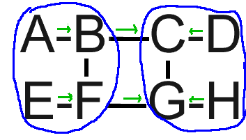
On Thu,  Jul 10, 2008 at 9:04 AM,  <[EMAIL PROTECTED]> wrote:
> But  geographical labelling does, and, it does NOT need any distribution
>  mechanism.

I should have added already here: I am not in favor of a BGP-like Routing
Table that contains geographical prefixes !!! I am not favoring collecting
routes, instead computing/distributing/collecting topological links of
different
zooming levels. And links can be marked. E.g. "Not for transit". Will  say,
your example doesn't manifest any problem.
I admit, I still have some problems by going for the "ultimate" which of
course is the more hampered by the incremental deployability issue. But your
example is not one of them.

If you look at the graph on _www.hummel-research.de_
(http://www.hummel-research.de)  you can see  many, many routes to the red
destination node which
caters for multipath,  traffic balancing, QoS/Policy-routing... Why not also
inter-domain-wise ?!
By knowing the topology you can do better policy-TE than without.  Sure,
after you have learnt shortest path, first. And the elimination of the
scalability problem is just a side-effect !

IMO I do propagate a different school of thought. It will also enable
different solutions with respect to rigidity versus compromises. In the past I
have
seen that the PNNI-architecture was given about 5 years of efforts,  although
(as I know now) it defeated itself: the hierarchical nodes became  bigger and
bigger, hence required a node-internal topology :-(. But if you  look at
GOOGLE MAP examples: that looks marvelous and does inspire to do  topology
aggregation or, if you want, to compose topologies of mixed zooming  levels.

IMO, research is about trying.

Heiner


Heiner,

As I'm pretty sure most everyone else on the list  has figured out,
routing based on geographic aggregation results in routing  policy
violations in any sufficiently complex internetwork.

Consider  the configuration of 8 nodes  at:
http://bill.herrin.us/network/geoag.gif

The black lines are  network links. The two blue circles represent
geographically proximate  areas, that is every node in the same circle
has the same geographic label.  The green arrows indicate who pays who
for transit service. Note the  absence of an arrow between C and G, and
between B and F: those are unpaid  reciprocal peering.

With both BGP and geographical routing, this  network is fully
connected. There are announced routing paths leading from  each node to
every other node.

With BGP, packets from D to F would  travel:

D-C(d pays)-G(e pays)-F(e pays)-E

With geographic  routing, they travel:

D-C(d pays)-B(oops!)-F(e pays)-E.

This  breaks a critically important part of routing policy! At every
router and  on every link, the source, the destination or both must pay
for that packet  to be there.

When are you gonna figure this out and move on from  geographic
routing? There are a couple  topological aggregation  variants which
still hold some possibility but geographic isn't one of  them.

Regards,
Bill Herrin


--
William D. Herrin  ................ [EMAIL PROTECTED] [EMAIL PROTECTED]
3005 Crane Dr.  ...................... Web: <http://bill.herrin.us/>
Falls Church, VA  22042-3004

--
to unsubscribe send a message to [EMAIL PROTECTED]  with the
word 'unsubscribe' in a single line as the message text  body.
archive: <http://psg.com/lists/rrg/> &  ftp://psg.com/pub/lists/rrg