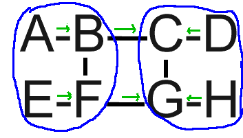
On Fri, Jul 11, 2008 at 2:32 AM,  <[EMAIL PROTECTED]> wrote:
> Based on: http://bill.herrin.us/network/geoag.gif
>
> Sorry Bill, but your proof is broken.You may consider your black lines as
> one or eventually two directed arrows (2 if opposite) and compute a path
> being a sequence of arrows all bound to the same endpoint.
No Heiner, you can't. The black lines describe only interconnection.
The green arrows describe permission. Regardless of the actual
interconnection, you may only choose a path for which you have
permission. Honoring permission is core to the problem definition, one
of the criteria any serious proposal MUST meet.

Think of it like this: If you want to go from London to Mexico City,
you can fly to Canada and then drive southwest, but ONLY if you have a
passport, both US and Canadian visas valid for the specific timeframe
of your travel and an international driver's license. If you lack the
visas or the license, or if you're on the TSA watch list, you'll have
to fly around the US to Mexico. Although the US is geographically in
between the two and other folks making similar trips are permitted to
enter and use US roads, you are not.

I have invited you to describe your algorithm's actual path selection
choices in a concrete routing scenario. All you have to do is type two
sets of five letters and then explain how you picked them. Instead,
you waved your hands about and said "no, no, that's not right."

I invite you one final time: demonstrate your algorithm's behavior in
the described scenario. Show that it picks paths consistent with the
given permission without disaggregating the geographic knowledge. Put
up or shut up.

-Bill Herrin


--
William D. Herrin ................ [EMAIL PROTECTED] [EMAIL PROTECTED]
3005 Crane Dr. ...................... Web: <http://bill.herrin.us/>
Falls Church, VA 22042-3004

--
to unsubscribe send a message to [EMAIL PROTECTED] with the
word 'unsubscribe' in a single line as the message text body.
archive: <http://psg.com/lists/rrg/> & ftp://psg.com/pub/lists/rrg