On Tuesday, December 11, 2012 00:40:16 Torsten Dreyer wrote:
> Hi,
>
> let me chime in here with a personal note, hoping it's not offending
> anybody.
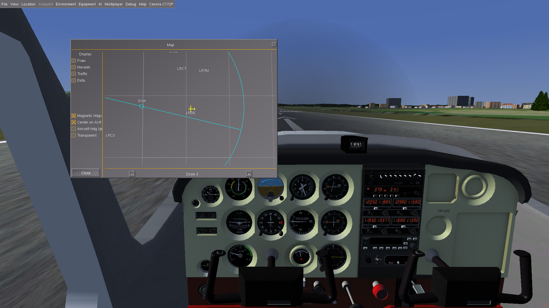
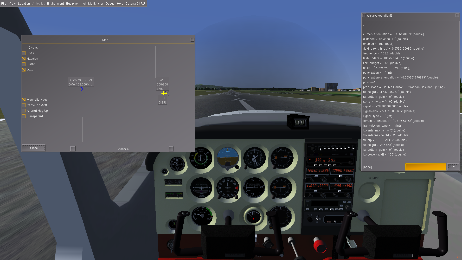
Hi Torsten, and thanks for your detailed message. Let me explain below why
realistic radio propagation should be inside Flightgear, and aleviate some of
the fears about performance (leaving aside the fact that I would leave the
system disabled by default, except for those who are really interested, like
flying in an area which requires realistic radio factors).

>
> Although I like having accurate and detailed computation of our
> real-world simulation, I'm not really a friend of the radio propagation
> code with the level of detail given. Please let me explain why that is
> the case:
> The radio stations used for aviation purpose certainly follow the same
> physical laws as any other radio station does. However, their
> performance have to adhere to some specific rules, mostly set up by the
> ICAO. Service volumes is on of these rules, a straight ILS final track
> is another etc. If real life's environment disturbes the performance of
> the radio stations, the operator has to work hard to override these
> environmental impacts. As we usually do not have any detailed
> information about how the radio station is set up (and I doubt, we will
> ever get those), it's close to impossible to correctly model radio
> probagation of a specific station.

Well, it certainly is possible to take into account terrain, free-space loss,
diffraction over mountain edges and other such stuff the ITM algorithms allow
for. All I know is that now, sitting on the ground 88 km away from a VOR
station, with hills in between, I have needle deviation. Impossible.
Please consider that having realistic radio navigation according to terrain
would be as far as I know a unique feature for any flightsimulator I've seen.
To refuse to add such a realism enhancing feature would be quite illogic to
me.


> Adding envirionmental factors besides
> terrain and terrain cover and the factors of aircraft installations will
> result in a wide range of uncertainty, spoiling all the detailed
> computation of the radio signal propagation.

Terrain, terrain landcover, and frequency of station are exactly the factors
involved in my calculations, the rest comes from published data and equipment
specs available all over the web. If needed, I can bring on board a
specialist, but I'd rather await request. If needed by a research project, any
station can be tuned like in the real world, and evaluated within the
simulator.

>
> As a pilot, I am usually just interested in the factor, if I am within
> the service volume of a radio station. If so, I'd expect a clear and
> correct indication, probably with the well-known system errors applied.
> If I am outside the service volume, the systems may show "something",
> but I do not really care about what exactly an ILS indicator (as an
> example) is showing.

I will make my case with just two screenshots, available from the wiki
article, re: published volumes.
http://wiki.flightgear.org/images/e/e0/Vor_no_itm.png  no real radio
http://wiki.flightgear.org/images/c/c6/Vor_itm.png  realistic radio

Or consider for DME equipment, which is very much more affected by terrain
than VOR, due to the 10x times higher frequency:
http://wiki.flightgear.org/File:Vor-no-dme.png  :VOR with no DME due to
propagation over edge of mountain for lower VHF freqs.
http://wiki.flightgear.org/File:Vor-dme.png  :VOR with DME measurement, once
obstruction was cleared.

>
>  From real life experience, I can say that barely two stations behave
> the same if you are outside their published range. Sidelobes of a
> localizer may appear at on site and may not at another site. False
> glideslopes appear here but do not show up somewhere else. It depends
> heavily on the local setup of the base equipment (and to some degree on
> aircraft installations). However, I have seen the shoreline effect of
> ADF stations deflection my ADF needle heavily and I have seen effects of
> nearby thunderstorms and lightning on the instruments. I'd love to see
> these effects modeled.

If I remember correctly, Flightgear used to be used also in university
projects, ARINC, etc. Has that changed? The ILS with it's two components is
modelled rather simplistic right now. But still it's not possible to receive
if obstructed by terrain, trees, buildings etc. Also, the fact that GS uses a
higher, therefore more prone to terrain/clutter interference than LOC, is
included. How would you feel to make an approach 10 km with a mountain turn
like some airports in Swiss, and have ILS indication even while behind the
mountains?

>
> That said, I think doing realtime radio signal propagations is much more
> that we need and much more than we want. At least unless we are
> multi-threading and have a spare CPU for those computations.

Thanks to your patient advice and a lot of time spent tuning the system, I can
say this: with 3 stations tuned in, the radio subsystem consumes resources
similar to instrumentation subsystem on the Cessna and Piper and sometimes
almost half that of the flight subsystem. I have provided plenty of options to
alleviate performance problems: from adaptive profile sampling to increasing
the distance between points, to increasing the delay between two calculations
for any station.
Can provide more info on that too if necessary.

I know you are a pilot, fellow amateur radio operator and one of the leaders
of the project. So please don't say that you would refuse a realism increasing
option, which would not even have to be on by default, and which is not
present in any other flightsim that I know of. It would be illogic, and would
limit the options of using Flightgear in other environments, like research
projects, university, aeronautical radio. It would also make a discouraging
statement vs. contributing to Flightgear.

I have not even gotten into detail on what kind of level of detail can be
implemented into ILS stations, so far as to have very slight failures, like
losing the 90 Hz modulated sideband, and having a wrong display indication.
As you probably know, a wrong instrument indication is probably more dangerous
than no indication.

Meteorological phenomenons affecting instruments, definetly can do.
Interfacing with FGCom, possible. Realistic radar in mountainous terrain,
realistic ATC (no more hearing that 300 km away tower), already done.

My suggestion is to include this feature, leave it off, and let anyone
interested turn it on.

Cheers,
Adrian


>
> This is certainly just my personal point of view.
>
> Greetings,
> Torsten
>
>
>
> ---------------------------------------------------------------------------
> --- LogMeIn Rescue: Anywhere, Anytime Remote support for IT. Free Trial
> Remotely access PCs and mobile devices and provide instant support Improve
> your efficiency, and focus on delivering more value-add services Discover
> what IT Professionals Know. Rescue delivers
> http://p.sf.net/sfu/logmein_12329d2d
> _______________________________________________
> Flightgear-devel mailing list
> [email protected]
> https://lists.sourceforge.net/lists/listinfo/flightgear-devel

------------------------------------------------------------------------------
LogMeIn Rescue: Anywhere, Anytime Remote support for IT. Free Trial
Remotely access PCs and mobile devices and provide instant support
Improve your efficiency, and focus on delivering more value-add services
Discover what IT Professionals Know. Rescue delivers
http://p.sf.net/sfu/logmein_12329d2d
_______________________________________________
Flightgear-devel mailing list
[email protected]
https://lists.sourceforge.net/lists/listinfo/flightgear-devel